Oregon the Beautiful
I will admit to being a "homer" when it comes to the state of Oregon. Although I only lived there for just a little over three years, our family has always thought of it as home because it is where my mother was born and raised, and it's where our father always promised us we would live once he was discharged from the Navy. I left it at age 18 and moved to the opposite end of the U.S. -- Florida. I have been back many times since, and recently three summers in a row. It always amazes me with its beauty and diversity. Yes, it does rain a lot, but it's not like the downpours we Floridians are used to. It's more like a mist. And that's what keeps it so green!
I want to focus this blog post on what I've come to term "the Northwest Loop." That means a trip that forms a sideways 8 with Portland as the center of the loop. It would take several days to complete the loop, but you could probably do it in 3-4 days easily, depending on how long you would want to stay at each place.
Let's start with the flight into Portland. If you're lucky, you might see this shot from your window (as I did).

Majestic Mt. Hood
Mt. Hood is only about an hour away from the metropolitan area of Portland. It is known for its year-round snow. Depending on the flight path, you can also see Mt. Jefferson, Mt. St. Helens, and maybe even Mt. Ranier from the air.
Let's start your trip in Portland and head directly to Mt. Hood. Along the way, you'll enjoy the tall trees along the very easy drive. As you get closer to the mountain, you'll play peek-a-boo with the mountain top -- as you round around corners or come to the top of the hill. The peak is at 11,000+ feet and it dominates the landscape.
You'll pass Government Camp, at which you could stop for snacks and a ride down the alpine slide. I highly recommend that you drive up to historic Timberline Lodge.

Timberline Lodge
Does it look somewhat familiar? Stephen King's The Shining was filmed there. The front facade has changed from when I lived in Oregon. Originally there was a long stone tunnel coming out the front, along which skiers would leave their skis and other equipment. My husband and I stayed in the original lodge once. The rooms are small and the bathroom was tiny. But it was still a thrill to stay there. One thing off my bucket list.
If you're looking for more modern accommodations, there is a more modern annex to it across the street.

The main lobby (second floor)
Timberline Lodge was a project built during the Depression to give out of work masons, artists, and other workmen jobs through the CCC and the WPA. The detail around the lodge is fascinating. The newels of the staircase rails are carved into wooden animals, for example. There are paintings, sculptures, and tapestries throughout. The lodge also has several restaurants and lounges available. On my last trip I had a lunch buffet at the Cascade Dining Room, and was seated at a table that gave me a terrific view of Mt. Jefferson, to the south.

Mt. Jefferson
As its name suggests, Timberline Lodge is at the timberline of the mountain, about 6,000 feet in elevation.

The lodge with Hood in the background.
Once you've explored Timberline to your satisfaction, go back to the main road and head to Hood River. You'll pass through lots of fruit farms along the way. Stop and buy some fresh fruit in the summer -- whatever happens to be in season at that time. We've gotten some good peaches, cherries, and berries on that trip.
Hood River is located on the south side of the mighty Columbia River and is known for its windsurfing. As you come into the town, look above the river and see all the parasails and "kites" used. It's quite a sight. I've never stopped there so I don't have a photo, but I enjoy the view "live."
Head back west towards Portland. Along the highway will be Multnomah Falls. It's a left exit if you want to stop (and I highly recommend that you do).

Multnomah Falls
The photo doesn't do it justice. The bottom half of the falls is cut off because my camera just couldn't fit it all into one frame. At the bottom is a nice area set up for photos or just relaxing. You can walk up to the top of the falls, or (like me), choose to stop at the bridge. The bridge was recently rebuilt because a boulder fell on it and damaged it. It's not a bad hike to the bridge, but it will take some time, especially if you're not in great shape. Also at the falls is a gift shop, snacks, and public restrooms. You might be lucky enough to be there when a train comes through, too. (The tracks are above, so no worries).
Once you leave Multnomah Falls, you'll continue west towards Portland. At some point, if you look up, you'll see the Vista House set up on the cliff overlooking the Columbia River. You can drive up to it (it's a little winding, but not bad.). On the way, you'll pass at least one or two lavender farms. From the Vista House, you'll have amazing views of the Columbia River east and west.
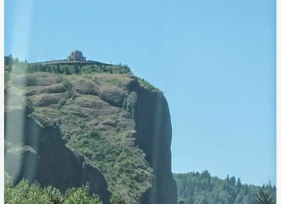
The Vista House as seen from a car.

The Vista House up close.

You may be lucky enough to have an in costume history guide giving a presentation!

The Columbia River, looking east from the Vista House.
Warning! It can be very windy up there so secure your hats!
From there, it's just a short drive back into Portland.

The motto of Portland, Oregon.
If you're going to explore downtown Portland, I would suggest riding The Max into town. The Max is a light rail system that is very reasonable. It will save you the trouble of one way streets and trying to find parking. I caught the green line at Clackamas Town Center, where there is a lovely, well lit and free parking garage for the transit system.

The Max
Taking the green line has you go over the Willamette (Will AM' ett) River and you'll get a glimpse of why Portland is also known as Bridge City.

There are two bridges in this shot.
Get off at the first stop on Burnside Street and walk up a few blocks to Powell's City of Books, probably the largest private book store in the US (if not the world). It's so big, they give you a map when you walk in! (Restrooms on the 2nd floor, by the way).

Inside Powell's City of Books.
There are three floors and a mezzanine. Oh, and an annex across the street. The people are very helpful. There's an information center on each floor, and all cash registers are on the bottom floor. They sell both new and used books, often on the same shelf.
If you're hankering for something special to snack on, further east just off Burnside you will find a nifty little place called Voo Doo Doughnuts.

Voo Doo Doughnuts 22 SW 3rd Ave
DO NOT EXPECT TO WALK IN AND RIGHT OUT. First of all, at 2 p.m. I had to wait 30 minutes to get my doughnuts. Once you are in, you are overwhelmed with the choices. It is so large that I'm just going to insert a hyperlink to their menu.
There are several other locations. Another one is at 1501 NW Davis Street, on the other side of the river.

Davis Street Voo Doo Donuts.
CAVEAT: Voo Doo only accepts cash. However, there is an ATM at both locations.
From here, you might want to go to Pioneer Courthouse Square, Portland's "living room." If you're lucky, you might catch a fresh market there.

Lavender being sold at the fresh market.
Portland is full of public art. Just stroll along the streets in the area and you'll probably find dozens of pieces of art, including the famous "Portlandia" sculpture that inspired the name of the cable series.
Head towards the waterfront. There is a long, long walk along the river, with pedestrians, bicyclists, even segway riders!

Waterfront park with geese (watch where you step).

McCall Waterfront Park

The river walk.
As you walk throughout the city, you might come across one of these. It's the famous Benson Bubblers! Perfectly safe.

Bubbler
There are a lot of museums in the downtown area. Portland State University is also within walking distance. You can also enjoy lots of shopping and cafes in the downtown. When you're done, just find the green line back to your car.
Another part of Portland you would probably like to visit is Washington Park where the Rose Test Gardens and the Japanese Gardens are located.

View of Portland from Washington Park.
Portland is known as The City of Roses (as well as Bridge City). Each year they celebrate with a Rose Parade with floats made of flowers and other plants. Washington Park has a section dedicated to the variety of roses in the area. Other flowers are also on display, but the roses are the main attraction.

You can't resist stopping and smelling the roses here.
Just down the block from the test gardens are the Japanese Gardens. Peace and serenity are the rule here. You will wind around paths and find something different around each corner. The Japanese Gardens have an entry fee; the rose garden does not.

A footpath next to the lily pads.
The Oregon Zoo and the Oregon Museum of Science and Industry (OMSI) are also in this area. I haven't been to either in about 20 years so I can't give you any information other than I have enjoyed both greatly in the past.
Once you've gotten a taste of Portland, head up US 26 to the coast. Along the way, you might stop at Camp 18. If you're really, really hungry, have a meal there. Otherwise, just stop and browse!

Wood sculptures at Camp 18.
Camp 18 has a huge restaurant (big meals), a gift shop, public restrooms, and lots of timber logging equipment on display. You can take a path out to the back and find a nice, peaceful river scene.
Once you reach Highway 101, you have a choice. You can go north, up to Astoria, which is a beautiful town that is seated at the mouth of the Columbia River (and has a view of the Pacific Ocean). Take the time to cross the bridge into Washington State, then come back over. The view of Astoria is breathtaking. Astoria is where several movies were filmed -- Short Circuit, The Goonies, and Kindergarten Cop are three of which I'm aware.
South of Astoria (and just a bit north of US 26) is Seaside, Oregon's first beach resort town. Plenty for families to do here -- arcades, gift shops, restaurants, beach fun, and lots of hotels and motels.

Seaside's historical importance is that this the end point of the Lewis and Clark trail, as this sign indicates. There is a commemorative statue behind the sign.
A little further south is one of the most recognized beaches in Oregon, Cannon Beach (named such when they found a cannon buried in the sand there at one time).

This warning is at the public entrance to Cannon Beach. You'll see these throughout your visit to the Oregon Coast. However, the chances of it happening are slim.

Haystack Rock and the Needles.
Many will recognize this rock formation from the movie The Goonies. But unlike the depiction in the movie, the rock is not hollow. However, it is home to hundreds if not thousands of sea birds, including the crowd favorite, the puffin. The water of the Pacific is FREEZING so only the very hardy can stand to be in it very long. You can rent peddle operated "go-carts" and go flying down the beach (avoid tourists trying to take photos, please). There are a lot of motels and hotels along the beach. Public parking is a few blocks from the beach, but the path is well marked. If you want to shop and eat, there are plenty of opportunities on the main drag.
You might want to stop at Ecola State Park near Cannon Beach, but the drive is slow and winding down to the beach. Take a moment to stop at an overview of Manzanita.

Manzanita
Keep going south and you will be turning inland. Don't be dismayed that you no longer have beach views. You will enjoy valleys and lakes. Take it easy if you're not used to driving curves, because there are plenty. There are a lot of little towns along the way to provide you with an excuse to stop and grab a drink or something to eat.
Finally, you will reach Tillamook and the very famous (at least to us) Tillamook Cheese Factory.

Entrance to the Tillamook Cheese Factory
This is a must stop! As soon as you go in, you'll see the ice cream counter with dozens of flavors from which to choose. There is also a free factory tour, and at the end of that, free samples of Tillamook cheese. Their basic cheese is a mild cheddar, but there are variations that include jalapeño peppers, garlic, colby, and jack cheese. My favorite is the "squeeky (sic) cheese" or cheese curds. They squeak when you bite them. You also can grab food (hot dogs, hamburgers), or shop in one of two gift shops. One is cheese and cheese related products (and Tillamook souvenirs), the other has general Oregon souvenirs. I enjoy looking, even if I don't buy anything.
Continue south along Highway 101 until you come to Lincoln City. Lincoln City was formed from 4 or 5 small communities so that they could share resources. It's about 6 miles long from north to south and each area has its own mystique. In the northern part you will find the Chinook Winds Casino. It is not huge, but if you like to play slots, it's a lot of fun.

The Casino also has a motel.
On my last trip, we chose to stay in the Taft area, which is on Siletz Bay. Boy, did we choose wisely. There was a lot of beautiful scenery and we actually saw wild life in its natural habitat!

Siletz Bay is home to a big group of harbor seals.
We just had to walk about a block and a half from our hotel to see this site. Along the beach were piles of driftwood and several families had bonfires going in the evening for cookouts.

It looks like fishing, but these men were actually crabbing with special cages at the end of their lines.

These boys actually caught two Dungeness crabs in their trap.

Mo's at Lincoln City
One of the staples of the Oregon Coast is Mo's. There are 5 or 6 restaurants (at least) along the coast. They're famous for their clam chowder, but also have lots of fresh seafood dishes. If you're not a seafood fan (like my sister), you can get a grilled cheese!

Mo's famous clam chowder.
Continue south to Depoe Bay. Depoe Bay is the world's smallest navigable harbor. Just a little north of it is the Dee River, the world's shortest river. Depoe Bay is known as a whale watching stop. You can ascend a two story tower and use a telescope to look out into the water. The last sighting of a whale is posted in the lobby. March and October are the busiest months, from what I'm told, but I've spotted them in the summer. Usually you can only see the spume, but occasionally you might see a back or even the tail come up out of the water.

Depoe Bay. On the left is the Pacific Ocean and to the right are all the tourist shops.

This is the ocean side, not the bay.
South of Depoe Bay, almost to Newport, is Otter Rock, home of The Devil's Punch Bowl. The punch bowl is a rock formation in the water that can fill with water during high tide.

Devil's Punch Bowl.
During very low tide, you can actually descend into the Punch Bowl via a beach to the north. The rocks are slippery. You really don't appreciate the size until you see it from the ground! It is huge.
This is another place where you might view whales. Keep an eye out for the whale watching boats that are out there. If you see them close together, chances are there's a whale in the area.
Keep driving south until you reach what is probably my favorite coastal city, Newport. If you've seen Overboard with Goldie Hawn and Kurt Russell, you've seen Newport Harbor.

Newport is on Yaquina Bay.
Finding the bay harbor area is a little tricky. Keep an eye out for the signs along 101. We ended up going a back, roundabout way. Parking around lunch time is at a premium! It is a working fishing area so most of the bay side is taken up by the fishing companies, but across the street are all sorts of shops and eateries. The shops offer everything from kitschy souvenirs to one of a kind craft items. There's a Mo's there, but I've eaten at the Rogue Ale House and it's also good (and they give you a free sample of beer).
If you go onto one of the short boardwalks / piers, you may see sea lions in the bay. Sometimes there are quite a few and quite noisy. But during this last visit, I only saw two far out in the bay, silently swimming. You can also see the fresh catches -- salmon and crabs among the most frequent creatures.
The bay area is at the south end of Newport, but since Newport is your most southern point at the end of the "loop," you will turn back north. If you have time, you can stop at one of the beaches along the way.

Nye Beach, Newport.

Agate Beach with Yaquina Head lighthouse in the background.

Yaquina Head lighthouse (it's in a fee area).

Harbor Seals at Yaquina Head natural area.
Take Highway 18 back to the Williamette Valley (head towards Portland). About 30 miles inland you will come to Spirit Mountain Casino, if you want to try your luck! It's a bigger, more modern casino than Chinook Winds, but I wouldn't call it better (of course, I'm not a gambler, anyway).
Once you leave Highway 18, take the roads that will lead you back to Portland. Eventually you will take I-5 and then 205 back into the city.
I hope you've enjoyed our trip through my adopted home state!

Mt. Hood overlooking a farm in the Willamette Valley.
posted by Shakespeare's sister at 12:24 PM
|
0 comments
![]()
